It’s been hard for public station personnel to accurately predict service coverage — for both radio and television — since the digital transition began.
NPR Labs is hoping that its new interactive online mapping system offering such coverage prediction will help the engineers and managers of approximately 3,000 public radio and television broadcast stations and translators, get a better handle on their predicted analog and digital coverage on automotive, mobile handheld and indoor receivers.
The online mapping system is here.
NPR Labs Senior Technology John Kean tells me that the online mapping system will allow overlays to compare analog and HD Radio at the original and higher FM power levels. It includes exact locations for transmitters and FM translators and population coverage predictions.
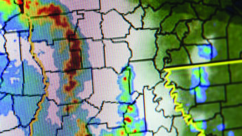
(click thumbnail)
The new NPR Labs interactive online mapping system, displaying projected DTV fixed receiver coverage for WMFE(TV,) Orlando, Fla. at left and projected DTV mobile receiver coverage at right. Images courtesy NPR Labs
(click thumbnail)


Using the system will help radio stations “see how much more coverage the FM digital power increase would get them,” Kean says.
The DTV coverage, especially the mobile handheld coverage, will predict how well viewers may be able to receive full service and translator systems. The ATSC-M/H coverage was developed with assistance from the Open Mobile Video Coalition.
“The demographic data is ideal for gauging and comparing coverage for actual populations, which planners and underwriters may use,” Kean says.
The online mapping system is free and open to everyone. It works best with online browsers such as Chrome, Firefox and Internet Explorer 9 and above.
Users can search by call sign, address, even latitude and longitude. The map jumps to that location and shows all the stations in the area. The analog FM coverage, as well as HD Radio coverage at the original digital power level of -20 dBc and also -14 dBc, reflecting the blanket digital power increase, are available. You can adjust the transparency of the overlays, zoom at will and change the background from terrain to roads or satellite view.
The maps also include commercial station locations and basic information about those stations.
Lots of engineering groups advised NPR Labs on the project, including Jim Kutzner and Eric Wolfe, Public Broadcasting System and members of the PBS Engineering & Technical Advisory Committee along with Victor Tawil, Association of Maximum Service Television, which is now part of NAB Technology. Members of the Open Mobile Video Coalition, Charles Cooper of du Treil Lundin & Rackley, Jon Dewitz of the U.S. Geological Survey and Rob DeBolt, retired from the Institute for Telecommunications Sciences also lent a hand in the effort.