Gary Cavell is president of Cavell, Mertz & Associates. We interviewed him for the ebook “Maximizing Your RF Coverage.” This is an excerpt.
RW: What strategies are available to fill in gaps and fix other signal challenges?
Cavell: Before delving into possible solutions, make sure you understand the nature of the problem, unless it is painfully obvious. Look at the geometry of the transmitting location vs. the location of the areas of concern, along with the transmitting antenna height. Is there intervening terrain, foliage or cultural features like buildings that may impact a clear view into the community?

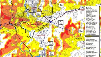
Then use reception prediction tools starting with optical shadowing studies, and Longley-Rice received signal studies. Be sure to crank in the program’s “land use / land cover” options. Also, know that the default receiving antenna height is typically 30 feet above ground. I prefer to use a more realistic 6 feet.
Once I create a Longley-Rice coverage map based upon the theoretical predicted levels and realistic receiving antenna heights, I ask the station owner to look at the map and tell me how this lines up with their actual reception experience and regions where there are perceived problems.
I also separately look at predicted INCOMING potentially interfering signals to see if the areas where coverage issues exist are really interference-driven, which may dictate the use of a different approach for resolution.
Finally, look at the locations of other stations’ transmitter sites within the “poor reception” areas. Is the problem localized brute force overload or receiver-induced intermodulation interference?
All of these factors can figure into how the problem can be addressed. It is at that point that we then start looking at relocation, on-channel booster feasibility, fill-in translators, use of HD channels on other stations, and the like.
[Sign Up for Radio World’s SmartBrief Newsletter]
RW: How can a broadcaster assure that actual performance lives up to the predicted coverage?
Cavell: It’s impossible to provide absolute assurance of performance, since there are so many variables to the transmission/reception equation, many of which are beyond the station’s control. I feel that the best that we can do is to provide relative comparative information based upon the best available methods recognized and accepted by our industry.
Before contemplating any changes, I traditionally recommend creating a Longley-Rice coverage map based upon the existing facility; theoretical signal levels for various levels of performance like urban vs. rural; expected building attenuation factors; and realistic receiving antenna heights and terrain factors. I then ask the station owner to look at the map (and preferably driving around with it) and tell me how this lines up with their actual reception experience and regions where there are perceived problems.
This establishes the “before” coverage conditions against a possible solution generated in an “after” coverage map — provided that the station owner “calibrates” their mind (and ear) using the “before” map. All of this assumes that the existing (and newly constructed) antenna and transmitting system is operating properly and as designed … otherwise the comparison will be flawed.
Another means is to do an actual before vs. after “in the field” measurement of the signal using scientifically based methods such as those set forth in the FCC’s rules — mobile ground-based measurements using the decades-old techniques and analysis means — or some of the newer automated signal analysis boxes using car-top receiving antennas. Both methods are subject to localized influences and errors that affect accuracy, with the “traditional” “FCC method” likely being the most defendable. While tedious and potentially expensive, this is perhaps the best method of scientifically assessing existing coverage and comparing it to the post-installation solution.
The newest tool is the use of drone-based antenna pattern measurements, which is a technique we had a hand in developing. Where feasible, these are useful for verifying whether an existing antenna is having performance issues or is operating differently than intended, or to compare an “as-installed” antenna’s pattern to a replaced antenna’s pattern (pre- and post-construction checks), or that the as-installed antenna reproduces a vendor’s published azimuth and elevation patterns.
While the drone-based technique is usable in determining antenna pattern performance, antenna performance is but one part of the complex propagation / signal reception equation. As such, this alone should not be considered to be the sole indicator of ultimate reception in a station’s service area.
Read the full interview in the “Maximizing Your RF Coverage” ebook.
