Put the Global Positioning Satellite System to Work And Make Your Life in the Field Simpler
AM field strength/proof-of-performance measurements have been a staple of broadcast engineering since our industry came into being. Such measurements are used by the FCC and engineers for allocation purposes, to determine the ground conductivity along a certain path, to show that a non-directional antenna is producing a certain inverse distance field (IDF) and to show that a directional antenna system is actually producing the authorized pattern.
Other than licensed monitor points, measurements are not made at “spot” locations; rather, many measurements are made on radial paths because a lot of factors can influence the instantaneous field intensity at a given location. Ground conductivity and dielectric constant, localized reradiation, attenuation from buildings, trees and other surface objects, and other unidentified factors can and do affect the field strength.
In a perfect world, the measured field strength along a radial path would follow the inverse distance line. In other words, the field strength would be inversely proportional to the distance from the antenna, and E x D would always produce the same number.
In the real world, however, the field strength approximates the inverse distance line, and E x D is roughly the same for each point with instantaneous departures that can, in some cases, be considerable.
It is because of these real-world effects that we (a) take a lot of measurements on each radial, and (b) graphically analyze the data. Having more data allows us to better see the trend (and we can toss out errant points), and graphical analysis allows us to see what inverse distance line or conductivity value that the data points best fit.
The key to making good measurements is in knowing one’s location.
Small is a big deal
In the old days, we used 7-1/2-minute topographical maps. The antenna site location (ND radiator location or center of array) carefully was plotted on the central map and then radial lines were drawn outward from that point and onto adjoining maps to a distance of 32 km or more.
There is a lot of potential for error in laying out radials on topo maps. Over the years, I have laid out a lot of radials, usually on the transmitter room floor. Topo maps are necessarily large, and a typical map or drafting table simply isn’t big enough. The environment in which the radials are plotted is thus often less than ideal.
Also, the accuracy of the protractor or plotter used to determine radial bearings usually leaves a lot to be desired. A typical protractor has a radius of three inches, which corresponds to a little less than 2 km on a 1:24,000 topo map.
Largely because of the distances involved, AM proof radials often do not fall on whole number degree values, so the engineer laying out the radials has to interpolate between degree marks on the protractor. Assuming that the protractor was oriented properly with respect to true north in the first place, an error of 0.5 degrees or more can easily occur. This corresponds to an error of about 1,000 feet at 32 km.
Errors at a considerable distance from the tower site are not as critical as those close in. Errors of even a few feet at short distances are significant, particularly on tight null radials. Close in, plotting errors are not so much a problem as navigation errors. Relying on automobile odometer indications from known (and mapped) landmarks has potential for great error, and yet this is the means by which engineers have for many years determined the location of measurement points.
Lock in
With the advent of the Global Positioning Satellite system, engineers now have at their disposal a means of much more precise navigation.
In the early years of GPS, engineers jumped on the technology for far-field measurements. The tower location or center of array could be programmed into a handheld GPS receiver, and as the engineer navigated, the distance and bearing from that point were displayed. It was thus much easier to know one’s location relative to the transmitter site.
There were, however, some problems with this.
For one, dithering is applied to GPS signals to deliberately limit the accuracy to civil users to 100 meters. Also, early user equipment provided only whole-number bearing information and 0.1 km distance resolution. Together, this meant that a user could be almost 0.5 degrees off bearing and almost 150 meters off in distance. Obviously, such positioning information would have limited value for AM field strength measurements, particularly for close-in measurements.
The GPS system consists of 24 operating ground-controlled satellites positioned in six orbital planes. There are four operational satellites and one spare in each plane. The orbital period is one half of a sidereal day (11:58). The orbits are close to circular and equally spaced about the equator at a 60-degree separation with 55-degree inclination relative to the equator. The orbital radius is roughly 26,000 km.
With this constellation of satellites, any location on the planet should, barring local obstructions, have between four and six satellites in view. Each satellite broadcasts its precise position on an L-band carrier. User equipment (GPS receiver) then computes its own position based upon these signals.
Standard or Precise
The GPS system provides two levels of service. The Standard Positioning Service (SPS) is for civil use and provides accuracy of 100 meters in the horizontal plane and 156 meters in the vertical plane. The Precise Positioning Service (PPS) provides much greater accuracy for military use. Some civilian use of PPS is allowed by special permit (surveyors, etc.).
One way around the inherent accuracy limitations of SPS is to measure the three-dimensional error vector from a known point and apply that to all GPS positional calculations within a fixed distance from that known point. The FAA has developed the Wide-Area Augmentation System, or WAAS, for just this purpose, providing GPS-equipped aircraft with much more precise GPS positional information than would be obtainable with SPS. Another work-around is the Differential GPS system set up by the U.S. and Canadian governments. Both systems operate beacon stations that transmit correction signals. Some high-end GPS receivers can receive and utilize WAAS and DGPS signals to correct GPS positional information. Tests have shown positional accuracy with WAAS correction to be on the order of 2-3 meters, and that’s good enough for even close-in AM field strength measurement work.
Modern GPS units also have the advantage of considerable processor power, color displays and mapping software. Depending on the amount of RAM in the unit, the user can load all the topo maps for the entire area into the unit. This makes navigation a snap.
Making GPS-referenced AM field intensity measurements is relatively straightforward.
First, make sure that the GPS unit employed is equipped with WAAS or DGPS (and if DGPS is employed, make sure it is available in your area; check at www.navcen.uscg.gov/ADO/DgpsSelectStatus.asp ).
Start with the reference point. Again, this is either the non-directional tower or the center of the directional array. In the case of most directional arrays, there will be different reference points for the close-in and far-field measurements. The close-in measurements must be referenced to the non-directional radiator. If the center of the array were used, many of the measurements would have considerable error. Once beyond 3 km or so, the array is itself a “point source” and the center-of-array coordinates should be used as the reference point.
Once the reference point is set, next set a waypoint for the end of the radial. For close-in measurements, set that at 3 km on each radial. For far-field measurements, make the end-of-radial waypoint somewhere beyond 32 km. Next, set a route for each radial starting at the reference point (center of array or ND radiator) and ending at the end-of-radial waypoint. All this can be done within the unit, but it is often easier to do in external mapping software. The reference point, end points and routes can be set and uploaded to the GPS unit along with the full map set. Maps can also be printed at a convenient scale to aid in navigation.
It is important to set the proper units in the GPS unit. Because the FCC requires metric units, set the GPS unit accordingly. Reference datum can also be set, and it should be set to match the map datum in use.
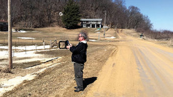
In the field, the user simply navigates to a point on the proper radial bearing. The GPS route screen will show deviation from the route and distance to the reference point. Walk or drive more or less perpendicular to the radial until the deviation is as close to zero as possible and note the distance to the reference point. The area is then checked for obstructions (overhead wires, nearby large metallic objects, etc.) and the field intensity is read on the meter. The distance and field intensity are then noted along with the time.
Conveniently, many handheld GPS units can be programmed to display the time on the same screen with the route distance/bearing, so it is possible to keep very accurate time records.
A team of one
With GPS, close-in “walk-in” measurements can now be “walk-out” measurements.
In pre-GPS days, a team of two people equipped with an FIM and a 50-meter rope (marked off in 5-meter increments) would start at a point determined by topo map to be exactly 3.00 km from the reference point on the radial of interest. The team would then work in toward the site, using the rope to measure distance and the FIM to “DF” the tower (which was often not visible because of trees and other obstructions).
When the tower was finally reached, the difference between where the team thought it was based on rope measurements and the actual tower location was noted and that correction factor was applied to the entire 3 km span. This makes perfect sense until you consider other measurement errors (rope stretch, obstacle circumnavigation, etc.). Still, it was the best we had and it worked.
A GPS-equipped “team” can now consist of a solo individual starting at the tower, navigating using the GPS and working out to 3 km. Rope errors are eliminated, and circumnavigation of obstacles is a snap. Such close-in measurements can become a combination of walk-out and drive-out, since it is not necessary to maintain a physical, linear measurement of distance on the ground.
The key to good directional measurements is repeatability. The DA measurement must be made at the exact same location as the ND measurement. In the past, this was achieved by a careful and thorough description of the measurement location, e.g. “Three paces west of the mailbox marked 10548, 0.4 odo. miles north on Powhaton Rd. from the intersection with C.R. 11.” It took a lot of time to write those descriptions, and multiplied by 20 or more points on each radial, this added a lot of time to each radial. Now, except in rare circumstances, distance only must be noted. That saves a lot of time and the DGPS/WAAS accuracy insures repeatability.
Repeatability is also the key to a good partial proof. The problem with partial proofs has always been in locating measurement points that were established years or even decades before. Things change, streets and roads are realigned, and it is often impossible to accurately locate certain points. GPS changes that, at least to some degree. If a location remains accessible (i.e. not fenced off or covered by a structure of some sort), with a good GPS-established location, you can get back there.
Monitor points have long been an issue in developing areas. It has been incumbent on licensees to periodically update the monitor point descriptions on file with the FCC. Often times, these MP descriptions are somewhat ambiguous anyway, but adding GPS coordinates to the description insures that the location can be found.
With the availability of high-accuracy GPS units, the process of making AM field strength measurements has been made much easier, faster and more accurate. What more could we ask for? Personally, I’m holding out for the self-tuning directional antenna.