Partial County Alerting allows broadcasters to tailor the dissemination of EAS messages to affected areas. It will be the subject of a panel discussion in the Broadcast Engineering & IT Conference on Monday of the NAB Show.
Adrienne Abbott is chair of the Nevada State Emergency Communications Committee. Tim Schott is a meteorologist at the Analyze, Forecast and Support Office of NOAA, while Dan Berc is warning coordination meteorologist with the Las Vegas Weather Forecast Office of NOAA and the National Weather Service.
Abbott answered our questions by email:
Radio World: What is Partial County Alerting and why does it matter?
Adrienne Abbott: PCA is a National Weather Service programming capability that provides broadcasters with EAS weather activations targeted specifically to the area covered by the broadcaster’s signal. At the same time, PCA also targets warning dissemination on NOAA Weather Radio (NWR).
Broadcast signals don’t stop at county lines and they may not cover an entire county. PCA works by dividing the county into subdivisions based on microclimates, weather patterns, broadcast footprints and other geographic factors.
PCA is addressed in the FCC Part 11 Rules detailing the EAS Protocol, 11.31(c), which states that a county may be defined by one or more “subdivisions” and there may be as many as nine subdivisions. For maximum communications clarity, the NWS and its broadcaster partners are using the phrase “county partitions” instead of “county subdivisions.” The broadcaster chooses which partitions apply to their broadcast area and very easily programs that information into their EAS equipment.
By utilizing county partitions, the EAS equipment will receive and rebroadcast only the EAS weather activations for the selected partitions. This increases the credibility of EAS weather activations because the broadcast audience doesn’t hear warnings that don’t apply to them.
RW: How does it work, technically?
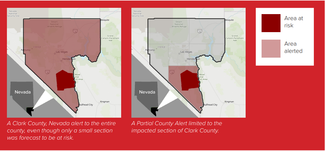
Abbott: PCA works well in Clark County, Nev., because the county is very large, larger than several East Coast states, and no radio or TV station has a signal that covers the entire county.
The most heavily populated area, and the one with the most broadcast signals, is the Las Vegas Valley. Before PCA, the Las Vegas broadcasters would receive EAS weather activations for storms which were outside the valley and confined to the rural areas of Clark County. With PCA, broadcasters covering the outlying communities such as Mesquite, Indian Springs or Laughlin receive and rebroadcast EAS weather activations for those areas, while Las Vegas radio and TV stations do not activate EAS, allowing their audiences to enjoy their usual sunny skies with no broadcast interruptions.
RW: Are there other particular parts of the country where PCA would be helpful?
Abbott: PCA is helpful anywhere a county has various ecologies and microclimates, geographic features like mountains, plains, valleys, canyons, lakes and seashores, and broadcast signals that don’t cover the entire area.
We have also found it helpful for counties with discrete population centers, which is exactly the case in Clark County. It’s particularly helpful for very large counties; in fact, the 29 largest counties in the continental United States lie west of the Mississippi River. While many of the large counties of the western states can certainly benefit from PCA, other areas of the country can benefit as well.
RW: How does the National Weather Service use PCA and what are its plans to expand it?
Abbott: The 122 Weather Forecast Offices, or WFOs, operate on a national software baseline. Six offices are currently employing PCA using local applications. However, PCA will be included in an upcoming software baseline deployment from NWS headquarters. We expect additional WFOs will on-board PCA for one or more of their counties in the first half of 2025.
RW: What has the experience in Clark County taught you?
Abbott: What we’ve learned in Las Vegas is that it can take time to see the benefit of PCA. The first year it was implemented, there was a very mild monsoon season with relatively few weather events that necessitated EAS activations. However, those activations were issued with PCA and we were able to see the benefit of this improvement.
RW: Which organizations in a given area need to be involved for PCA to be put to work in a given area?
Abbott: The FCC rules address this when they state, “Any subdivisions must be defined and agreed to by the local officials prior to use.” And that’s exactly what we have done. Planning for PCA implementation involves the Weather Forecast Office (WFO), the State Emergency Communications Committee chair and members, the state or local broadcaster association and state and local emergency managers. The Las Vegas WFO even conducted a public comment period. It’s a team effort to obtain input and implement this alerting improvement.
RW: What else should we know?
Abbott: If someone complains that there are “too many EAS activations” from the Weather Service, they should know that there are some options available to make those activations more applicable to their station. The place to begin this discussion is with the warning coordination meteorologist, or WCM, at their local WFO. They should work with their EAS SECC and their NWS offices to implement a solution that can improve their situation.