Unmanned aircraft systems (UAS) are rapidly carving out an important place in the toolkit that radio broadcasters use to manage tower sites more efficiently.
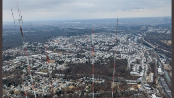
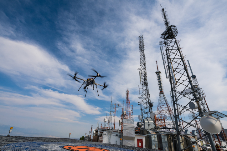
Drone-based tower structure surveys are used widely now to diagnose the health of RF systems and broadcast structures. In addition, tech departments use drones to take elevated RF measurements to analyze signal coverage and validate antenna radiation patterns.
The Federal Aviation Administration approved the commercial use of drones in August 2016. Industry experts say this unleashed an industry loaded with potential applications for broadcasters, including using video and still photos of broadcast antennas and their structural components for preventive maintenance measures.
“This is still a relatively new industry, where there’s so much creativity and potential. The integration of the technology has made a dramatic impact on broadcast operations,” one executive-level engineer told Radio World.
The FAA’s small unmanned aircraft rules (Part 107) allow a range of businesses, such as radio broadcasters, to use unmanned aircraft that weigh up to 55 pounds including their onboard systems. Drones must remain within line of sight of the remote pilot and be used during daylight hours.
The maximum altitude is 400 feet, though an exception allows more height when operating within 400 feet of a tall structure such as a broadcast tower.
“When surveying a tower, a drone is commonly permitted to fly an additional 400 feet above the top of the tower, if the aircraft remains within 400 feet of the tower laterally,” according to one expert.
Advocates say drones can more easily determine the integrity of transmission lines via infrared camera inspections and more safely and accurately assess antenna performance by limiting the amount of tower climbing and drive-by coverage analysis. While nothing can replace an actual physical inspection, they say a drone can help reduce the number of climbs, verify asset locations and heights on a structure, and increase safety.
Blossoming Services
A number of broadcast tech companies have expanded into unmanned aircraft services since 2016 as UAS have gained in popularity.
Paul Shulins, president of Shulins Solutions, said drones, used effectively, can help cut costs and increase safety margins for both humans and broadcast systems.
“The main operations that broadcast engineers use drones for are visual tower inspections, thermal tower inspections and antenna pattern verification measurements.” He said broadcasters are quickly discovering the advantages.
“Costs for tower crews vary wildly across the country, but in general it is fair to say that drones are less expensive to operate than hiring a tower crew. They can also be deployed with very little notice, operate in a wider range of weather conditions and provide perspectives not possible with a tower crew,” Shulins said.
Unmanned systems are becoming a preferred method for RF pattern verifications, he said, for reasons of both cost and safety.
“Drones have a clear advantage because typically these measurements can be made within a single day, where ground-based measurements can take several days or even weeks to accomplish. Helicopters are commonly used for pattern measurements as well, but are much more expensive to operate and are limited on how low they can fly.”
Recently, affordable, gyroscopically controlled infrared cameras have come on the market at a reasonable cost, Shulins said, though he added that drones will never replace human tower climbers for certain operations.
“What (drones) can do is help tower crews by pointing out areas in advance where problem exist though photos, saving time and labor.”
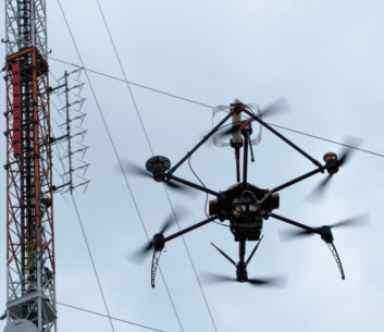
Jason Schreiber is managing director of RF measurement and consulting firm Sixarms, which has developed specialized RF measurement payloads to attach to drones. He says new RF measurement instrumentation can be adapted and installed on a drone and allow for automation and reliable data capture. In addition, the data can be used to optimize antenna patterns and verify radiated power.
“The automation, accuracy of signal capture, ease of flight, large altitude range and easy deployment make drone-based RF measurements a more attractive setup than the traditional van with a 30-foot pump-up mast. All broadcast standards can be measured, including AM radio, DRM, FM and HD Radio, VHF and UHF ATSC and DVBT as well as DAB,” he said.
Sixarms uses its off-the-shelf Airborne Radio Measurement Systems (ARMS) software and hardware to measure and characterize broadcast antenna patterns to help identify any installation and manufacturer defects.
He said the use of machine learning and AI to capture critical RF information will continue to grow and further expand the applications of drones for RF measurement.
Drones are being used not only to perform visual tower inspection but to identify damage and structural defects, Schreiber said, by making use of thermal imaging for hot spot analysis as well as being fitted with LIDAR (light detection and ranging) to help with automated structural analysis.
“Sophisticated capture algorithms interweaved with drone-based positional data allow for unprecedented accuracy and reporting functionality.”
Full-Time Coverage
The burst of drone activity in U.S. broadcasting is leading to more innovative tools and ways to use data, said Phil Larsen, VP of airborne operations for QForce, part of QCommunications.
“The RF contour is not just a report to be filed away anymore. It is now a tool, one to assist broadcast engineers and help the listener receive a better signal. The drone allows for engineers to review data immediately upon the aircraft landing,” he said.
Larsen hopes to see the broadcasting industry reach the point where a fixed drone is stationed at all tower locations that can remotely operated or programmed to fly routinely or whenever needed.
“Drones and the sensor capabilities are by oneself growing expeditiously, thus the use case will increase.” He said QForce offers a means of installing a drone at each location and the ability to fly inspection operations at any time of day all year long without the need of a pilot, autonomously. “This is specifically useful for hard-to-reach locations.”
There are some limitations to using drones near broadcast towers. The FAA has specific rules surrounding the inspection of broadcast towers. Operators must be familiar with FAA Part 107.65 rules, experts say.
In addition, Larsen said some broadcast tower applications do require FAA waivers or special permissions.
Antenna Modeling
Keith Pelletier, vice president of antenna manufacturer Dielectric, said drones are a much more economical way of collecting data than traditional field measurements and equipment.
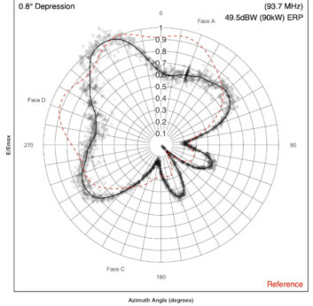
“Dielectric has developed a way to characterize the antenna azimuth and elevation patterns with the data collected by the drone. Typically this was done with a van with a large mast, which included multiple runs of data and thousands of points of collection to be analyzed to determine if the antenna was performing per the antenna manufacturer’s specifications,” he said.
The company’s involvement began when drone measurement companies started having difficulty with the waivers required and time spent on waiting for approvals. Dielectric came up with a method of collecting all the data required at the 400-foot level so no waivers were required.
Dielectric is able to assess whether electrical characteristics of the antenna are correct when measured only in the near field. “The Dielectric solution is to draw the entire array to analyze the near-field elevation pattern and compare that data to the near-field elevation pattern measured by the drone. The 3D rendering and analysis is done utilizing High Frequency Simulation Software, or HFSS,” Keith Pelletier.
Essentially the antenna’s far-field elevation pattern as simulated in HFSS is compared to what Dielectric measured at the factory to validate if its modeling is correct, said Pelletier.
“We then take the near-field elevation data collected by the drone to see if it matches up to the same cut in HFSS; and if so we know the far-field elevation pattern when formed is correct.”
There are several training programs available to get FAA Part 107 licensing, which is required for any type of commercial work. The exam requires an applicant to become familiar with FAA airspace regulations and a variety of other rules.
“It’s important to keep airspace safe. The hobby-type drones are fun but are not necessarily safe around towers, guy wires and high RF environments,” Shulins told Radio World.
“Either training and licensing yourself to operate a drone, or hiring a skilled licensed pilot with the right equipment and skillset to safely fly your tower and accurately interpret the results, is the smart thing to do.”
(This article originally was prepared as part of Radio World’s preview of the NAB Show so it cites only sources who planned to present at that convention. The NAB Show subsequently was cancelled. — Ed.)