The author is with Cavell Mertz & Associates Inc. in Manassas, Va.
May 2018 marks our first year for the measurement drone project development, which is now in operation for measurement of VHF and UHF broadcast antenna radiation patterns. This article updates some of our experience with the measurement platform and lessons learned, which includes some unique anechoic chamber testing.

The measurement drone is a complete receiving system, including an antenna, receiver and logging computer. Some may not consider the antenna to be as important as the receiver — after all, any piece of wire would pick up plenty of signal when in proximity to a high-powered FM or DTV transmitter. It is true that in flying around the antenna under test, we are just collecting the relative signal level according to azimuth, and the receive antenna performance is of little importance. However, the antenna’s performance can become important for other reasons, for example:
• Accurately measuring the level of signals on other frequencies, relative to the fundamental, such as harmonic or spurious emissions. This requires a known amplitude frequency response for the antenna, or, for individual antennas if used on different frequency bands.
• Rejecting signals from other sources. Operating at an antenna farm, other high-power stations may be on adjacent towers, which the drone has to maneuver between. Having a drone antenna with known directivity can help reject strong undesired signals.
• Reducing ground reflection effects. Target antennas that are relatively close to the ground may aggravate ground reflection effects. Use of an antenna with vertical directivity can minimize the impact of signals bouncing up from the ground.
• Accurately measuring vertical plane (elevation) pattern of target antennas requires the drone, which is flying level, to collect signals well above or below the flight plane. This requires characterization of the drone at other elevation angles.

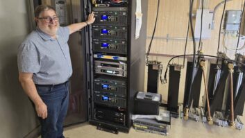
On a rainy day in early April, we had the opportunity to test the drone with Manuel Sone, manager of TV engineering at Electronics Research Inc. in Chandler, Ind., using ERI’s large-scale anechoic test chamber. This long, pyramidal test chamber is over 60 feet from end to end — built to test full-size sections of television and FM transmitting antennas, using a precision turntable system to rotate the antenna under test.

Fig. 1 shows the drone on a custom frame with Sone watching as it was bolted to the turntable by an assistant. The drone is atop the frame, fitted with a carbon-fiber tripod to support its antenna (the small log-periodic antenna in this case). The interior of the pyramid is lined with deep cones made of RF energy-absorbing foam, making the chamber “anechoic” from high VHF through microwave frequencies.
Cavell Mertz uses three different antennas for measurement, depending on the frequency range and directivity required. Fig. 2 shows the drone mounted with a small log-periodic antenna, covering 400 to 1,000 MHz, for UHF TV and cellular frequency bands.

Fig. 3 shows one of the firm’s drones with a bi-conical antenna, which operates from 50 MHz to 1,000 MHz, which covers all TV channels, FM and cellular communications.
A third antenna, shown in Fig. 4, is a ring-type antenna covering 80 MHz to 120 MHz. It was not tested, as the anechoic chamber is calibrated for the 170 MHz to 1,000 MHz frequency range.

MAKING THE MEASUREMENTS

In ERI’s normal tests with transmitting antennas, the antenna is connected by cable to a network analyzer, seen in Fig. 5. The two units underneath are used to control rotation of the platform and a calibrated reference antenna at the far end of the anechoic chamber.
The reference antenna is driven by an RF signal from the network analyzer, allowing a closed-loop measure of the antenna under test. In these tests, each drone antenna was mounted for normal flight and connected to the on-board receiver-logger system, allowing a comprehensive measurement of the drone’s receiver system, as in real flight.
The network analyzer and reference (antenna at the end of the chamber) provided a calibrated free-space test environment. This allowed us to calibrate absolute level measurement with the drone system — valuable in knowing the radiated power of the transmission, not just pattern uniformity.

Tests were conducted on the two antennas in the E plane (co-polar) with both horizontal and vertical polarization, and with cross polarization at some frequencies. This resulted in a large matrix of data but is too large to report here. As examples, Figs. 6 and 7 illustrate two measurements with the log-periodic antenna at 497 MHz (TV Channel 18).

The first polar chart shows the horizontally-polarized, horizontal plane pattern, with front-to-back and front-to-side ratio of more than 17 dB. This directivity can help in cases with reflections from nearby towers, which can happen at antenna farms.
The second chart shows the pattern of the antenna if it were mounted for horizontal polarization, but if the radiation were received above, below and behind the drone. This would be essential in measuring the elevation pattern of a transmitting antenna, as the drone ascends in front, moving through different pickup angles. All of these drone tests will be important in accurately characterizing signals from DTV and FM stations.
CRITICAL ALTITUDE

Moving to recent flight test experience, we learned the value of precise altitude measurement, illustrated in Fig. 8. The diagram shows a drone on the right flying at the lower edge of the main beam in blue (this could be defined as the 3 dB pattern, or another dB-down value from the beam maximum).
The white triangle inside the beam indicates the angle from the beam center to the drone’s instant elevation. The drone is shown at the “radiating far-field distance” although measurements are often taken at smaller radii as this can be a substantial distance in some cases. (Measurement at this distance ensures that the signal from all the elements has converged sufficiently to represent the far-field performance. At smaller distances, the accuracy of measurement can be reduced by the different vector arrivals from the array elements.)

Table 1 shows a scenario for an FM transmitter using an eight-bay, full-wavelength spaced antenna. An example of the elevation pattern for this antenna, in relative field, is shown in Fig. 9. Using the Fraunhofer equation, this array would have a radiating far field at 98 MHz of 1,088 feet. The scale at the top extends from the radiation center to 1,100 feet. The second line and third lines are set for no beam tilt, as may be common for this antenna system, assuming a radiation center height of 500 feet above ground.

The main beam width to –3 dB (0.707 relative field) is typically 6.3 degrees for this antenna. The elevation on the lower side of beam, on the fourth row, is calculated (in linear angle) from the radiation center. The last row indicates the change in elevation from the main beam, or to put it another way, the amount the drone can drift below the ideal center, to the nominal (–3 dB) beam edge. These are moderate tolerances, although uncorrected GPS elevation could drift by more than tens of feet within the time span of a measurement flight.

The next scenario describes a case for digital television, which use higher gain, and therefore higher vertical directivity, than FM arrays. In the UHF band, slotted arrays are often in the range of 24 to 30 “bays” (to use a VHF term). This can result in an elevation pattern beamwidth of less than 2 degrees. As a result, these stations usually combine beam tilt, to direct signal toward the coverage area.
Table 2 shows a scenario for a mid-band (channel 29, 563 MHz) station. The beamwidth is 1.9 degrees, with a beam tilt of 0.5 degrees. An example of the elevation pattern for this antenna, in relative field, is shown in Fig. 10 — a tremendous difference from the FM antenna.

With high directivity in the vertical pattern, the radiating far field distance is also increased, which for this antenna is calculated to be 2,120 feet, around 4/10 of a mile. Table 2 shows the results in 200-foot increments out to 2,200 feet. As above the beam center altitude is shown at each point, taking into account the beam tilt for an assumed height of 1,000 feet above ground.
In this case, the beam center drops slightly with distance, being 946 feet AGL near the far field point. The fifth row shows the lower edge of the beam, with beam tilt, and the last row shows the vertical different between that lower edge and the center of the beam.
For example, at 2,200 feet distance, the lower edge of the beam is only 35 feet below the ideal place for the drone to measure, at the beam center. This is a difficult maneuver to perform, as the drone flies a circumference of approximately 2 1/2 miles.

VERTICAL DRIFT
We have already encountered this kind of requirement in drone measurement and use differential GPS to achieve sub-meter elevation accuracy. This requires a long-range radio link between the ground reference and the drone, so that the drone’s navigation computer maintains the precise altitude, without error from the GPS’s vertical drift. We learned the hard way, when the differential mode was not engaged, by seeing the horizontal pattern wobble as the drone drifted — only by a couple of meters — up and down over the vertical radiation pattern. We are watching that like a hawk, from now on!
I would like to express my great appreciation to ERI’s Manuel Sone for his hard work in performing the measurements and many good ideas. Many thanks also go to ERI President/CEO Tom Silliman for making the company’s unique facility available for our testing.
Comment on this or any story. Email [email protected].
Also, here’s a cross reference for reading another story on drones: